Sunday, May 31, 2020

POLITY OF ANDHRA PRADESH 


The State of Andhra Pradesh was originally formed in 1956.

The language of most of the people in the State is denoted by the terms Telugu or Andhra, although they bear no phonetic or etymological affmity. 

There were two important stages in the formation of the State. At the time of Independence, the Telugu-speaking people 
were concentrated in the old multilingual Madras State and the princely State of 
Hyderabad. 

The Telugu-speaking areas of the Madras State were separated on 1st October 1953 to create the 'Andhra' state, with Kumool as capital. 

This Andhra region itself was composed of two sub-regions, namely the Andhra region 
(popularly called the Andhra), and the south interior region, known as Rayalaseema. 

Later, the Telugu-speaking districts (referred to as Telangana region) of the old Hyderabad Statewere merged with the Andhra State on 1st november 1956 under the State Reorganisation Act, to form the greater Andhra (Visalandhra), called Andhra Pradesh. 

Hyderabad, the former capital of the Nizam State, became the capital of the enlarged State (Rao, 1988; Narayana Rao, 1973; Sarojini, 1968; Venkatarangaiah, 
1965). It was the first State in Independent India to be formed on linguistic principle, 
creating one unified State for people speaking one language. 

Historians disagree on how these two terms came to be used to denote the same people. 

Some say that the Andhras came to the region from northern parts of the Indian sub-continent as part of their southward expansion. 

They found a comparatively developed people here whom they called the Nagas. 

The language of the local people was non-Sanskritic, and they probably called themselves Tillingas or Telingas. 

Both peoples lived together and united into one. 

The crossing of the Telugu/Tmugu and the Adhm gave rise to a hybrid and the synthesis has been so perfect that the two terms Andhra and telugu became synonymous with each other(Hamamantha Rao, 1996; Nagabhushana Sarma and veerabadra Sastry, 1995). 

NATURE AND ENVIRONMENT
 
Andhra Pradesh forms a major cultural and geographical link between the northern and southern parts of India. 

It is situated in the tropical region between the latitudes 1 3-20°north, and the longitudes 77-85" east.

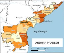
It was bounded by the Bay of Bengal in the east, Orissa in the north-east, Chattisgarh and Maharashtra in the north, Karnataka in the west and Tamil Nadu in the south. 

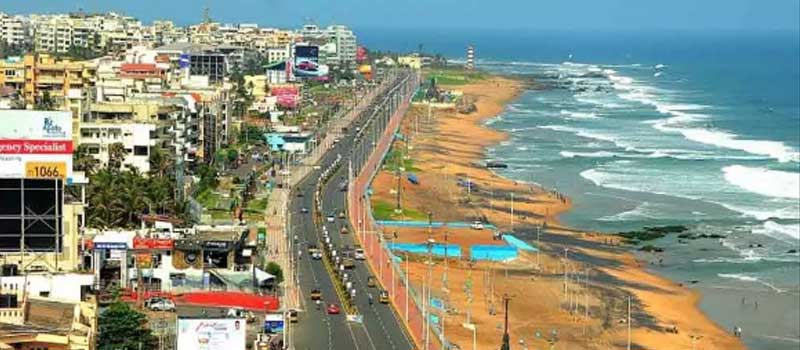
Andhra Pradesh has the second longest coastline in India (972 krn), running fiom Ichchapuram in Srikalculam district in the north to Sriharikota in Nellore district in the south. 

There are eight working ports in the State, including one major port (Visakhapatnam) and two intermediate ports (Kakinada and Machilipatnam). 

Krishnapatnarn port in the private sector is also making great progress. 

Andhra Pradesh is also rich in a variety of minerals, the most important of them being coal, limestone, natural gas, barytes, manganese, mica and iron ore.
 
Much of the industrial growth of the State is in mining and industries dependent 
upon these minerals.

POPULATION CHARACTERISTICS 

Andhra Pradesh was the fifth largest State in India, in terms of both area and population. 

In 2001, the State's population stood at 75.73 million (Census of India, 2001), which accounts for 7.4% of India's total population.

The sheer enormity of the State can be gauged against the fact that only 12 nations of the world have a population larger than that of Andhra Pradesh. 

The State population has more than 
doubled since its formation, although its decennial growth rate of population came 
down to 13.86 between 199 1 and 2001.
 
Literacy rate in Andhra Pradesh increased fiom 44.1 % in 1 99 1 to 6 1.1 % in 
2001, but it is still lower than the all-India figure of 65.4%.

The difference in literacy rate between rural and urban population, tribal and non-tribal people, socially backward castes and the upper castes, and males and females is still very wide. 


Friday, May 29, 2020

Visakhapatnam

Weather: 34 °C, Wind S at 19 km/h, 68% Humidity
Population: 20.4 lakhs (2011)


Visakhapatnam is a port city and industrial center in the Indian state of Andhra Pradesh, on the Bay of Bengal. It's known for its many beaches, including Ramakrishna Beach, home to a preserved submarine at the Kursura Submarine Museum. Nearby are the elaborate Kali Temple and the Visakha Museum, an old Dutch bungalow housing local maritime and historical exhibits.

Palm-lined Yarada Beach lies to the south, while sandy Rushikonda Beach is to the north. Connected to the seafront by a cable car, Kailasagiri Hill offers panoramic views of the city and the Dolphin's Nose headland, plus rides on a mini train encircling the summit. The peak is topped by a giant Shiva Parvati statue. Outside the city center are the Simhachalam Temple, a 11th-century Hindu shrine, plus the Kambalakonda Wildlife Sanctuary. Near the quiet beach of Bheemunipatnam are a ruined Dutch fort and cemetery. Farther northwest are the Borra Caves, a limestone labyrinth in the Eastern Ghats mountains, and the Katika Waterfalls.


Visakhapatnam is a port city in Eastern coast of Andhra Pradesh. Popularly called as Vizag or Vizagapatnam. It handles bulk of Indian export to different parts of world. It is major commercial and industrial center and has many beautiful places which attracts tourists from various parts of the country. Visakhapatnam is also the headquarters of the Eastern Naval Command of the Indian Navy.
visakhapatnam city information

Demographics

The population is nearly 10 lakhs. The average literacy is 69%. Male literacy is 74%, and Female literacy is 63%

Climate of Visakhapatnam

Being close to the sea, Visakhapatnam has no appreciable seasonal changes. The level of humidity is high. The fluctuations in temperature are fairly uniform in character. May is the hottest month. December and January represent the coldest period of the year. Visakhapatnam receives the bulk of the rainfall from north-east monsoons.

How to reach Visakhapatnam?

Rail:

Since Visakhapatnam is a major Industrial center it is well connected by rail routes with other parts of India. The major trains that connects visakhapatnam with other parts of India are:
  • Godavari Express from Hyderabad to Visakhapatnam
  • Visakha Express
  • Falaknuma Express
  • East Coast Express
  • Ratnachal Express
  • Janmabhoomi Expre
  • SS Coromandal Express
  • Madras-Howrah Mail
  • Howrah-Madras Mail

Roads:

Through state bus corporation bus service is available. Private operators also provides bus services and carry passengers to different part of the sates from and to visakhapatnam

Air:

It is connected to all the four Metropolitan cities through air route. Air India, Sahara and Air Deccan provides air services to the passengers.

Tourist Destinations

The major attraction of Visakhapatnam are beaches, caves, hills etc. The hot spot for tourists are:
Ramakrishna BeachRushikonda BeachKambalakonda Beach
Kailashgiri HillsBorra CavesSubmarine Museums
Naval Museums

Economy

  • The mainstay of Visakhapatnam's economy is heavy industries. Since there is a port therefore every major and minor industries have set up their base.
  • Visakhapatnam is a major fishing port
  • Apart from heavy industries there are many I.T based industries in Visakhapatnam.
  • Vizag Special Economic Zone is playing major role in the expansion of industries in Visakhapatnam.

Industries

The major industries of visakhapatnam are:
  • Hindustan Shipyard Limited
  • NTPC
  • HPCL - Oil Refinery (Hindustan Petroleum Corporation Limited)
  • Bharat Heavy Plate and Vessels Ltd (BHPV)
  • Hindustan Zinc Limited
  • Rashtriya Ispat Nigam Limited (RINL)
  • Coramandel Fertilizers
  • Rain Calcining Limited
  • Essar Pelletization Plant

Saturday, May 23, 2020

Current Affairs 2020


1. Medical Termination of Pregnancy (Amendment) Bill, 2020 passed by Lok Sabha

The bill seeks to increase the upper limit of legal abortions to 24 weeks for special categories of women such as rape survivors or victims of incest.
The Medical Termination of Pregnancy (Amendment) Bill, 2020 was passed by the Lok Sabha on March 17, 2020. The bill seeks to amend the Medical Termination of Pregnancy Act, 1971 and increase the upper limit of legal abortions to 24 weeks for special categories of women. 
The bill was passed in the lower house of the Parliament through a voice vote. Union Health Minister Harsh Vardhan stated that the proposed bill seeks termination of pregnancy in cases involving victims of incest, rape survivors, minor girls, differently-abled girls or in case of a pregnancy that has substantial foetal abnormalities.
The Union Cabinet had approved the Medical Termination of Pregnancy (Amendment) Bill on January 29, 2020 under the chairmanship of PM Narendra Modi.
Medical Termination of Pregnancy Amendment bill: Key Features
 The Medical Termination of Pregnancy (Amendment) Bill, 2020 proposes requirement for an opinion from one provider for termination of pregnancy up to 20 weeks of gestation and introducing the requirement of opinion from two providers for termination of pregnancy up to 20-24 weeks of gestation.

 The amended bill proposes increasing the upper gestation limit from 20 to 24 weeks for special categories of women such as vulnerable women including survivors of rape, victims of incest and others such as differently-abled women and minors.

 Under the amendment bill, the upper gestation limit will not apply in cases of substantial foetal abnormalities diagnosed by the Medical Board. The composition, functions and other details of the Medical Board will be prescribed subsequently in Rules under the Act.

 Further, the name and other details of the woman whose pregnancy has been terminated shall not be revealed except to a person authorised by the law.

2. Operation Vanilla: All You Need to Know about Indian Navy’s support to Madagascar

INS Airavat arrived at Madagascar's Port Antsiranana on January 30 with the relief material.
Operation Vanilla in News: The Indian Navy launched ‘Operation Vanilla’ on January 28 to provide relief and assistance to the cyclone-hit population of Madagascar. INS Airavat arrived at Madagascar's Port Antsiranana on January 30 with the relief material. 
INS Airavat, deployed in the Southern Indian Ocean, was diverted to Madagascar as a part of Indian Navy's 'Operation Vanilla' to provide humanitarian assistance and disaster relief to the people in the cyclone-ravaged areas of  Madagascar.
• About INS Airavat
INS Airavat was commissioned in the Indian Navy on May 19, 2010. It is the Indian Navy’s one of the biggest and heaviest naval ships. It is capable of carrying 10 battle tanks, more than 500 troops, and 11 combat trucks. INS Airavat provides a comfortable platform to Sea King and Dhruv helicopters. It is also equipped with two indigenous rocket launchers to provide support in amphibious operations.
• About Operation Vanilla
Indian Navy Ship Airavat reached Seychelles to provide all necessary help to Madagascar. The INS Airavat carried five pallets each of victualing, naval stores and clothing and three pallets of medicines.
The Indian Navy provided drinking water, emergency food, clothes, temporary shelters, evacuation-related help, medical assistance, emergency transportation and communication assistance to the people of Madagascar. “Operation Vanilla” is a part of the Government of India’s scheme – ‘Security and Growth for all in the Region (SAGAR)'.
• Where is Madagascar?
Madagascar is a country located in the Indian Ocean, about 400 kms away from the coast of East Africa. Madagascar is the world’s second-largest island country after Greenland. 
About Madagascar Disaster
Madagascar was severely affected by cyclone Diane recently. Around 92,000 people were affected due to floods in the country. President of Madagascar, Andry Rajoelina, had requested the international community to help the country with all possible measures. Heavy rainfall, floods, and landslides caused the loss of thousands of lives and the displacement of a large number of people.

3. Delhi Election 2020: Schedule, voting date and all you need to know!

Delhi Election 2020: The Election Commission appointed Retired IAS officer Vinod Zutshi as a special general observer for Delhi Assembly Elections 2020. Mr Zutshi was previously associated for 7 years with the Election Commission of India.
The appointment of Special General Observer comes in the wake of the poll preparedness meeting held between Delhi chief secretary, Commissioner of Police, Delhi Chief Electoral Officer and Senior Members of Delhi Government.
The EC had earlier appointed former IRS officer B Murli Kumar as special expenditure observer and former IPS officer M K Das as special police observer for Delhi Elections 2020. 
• AAP's "28-point guarantee card" 
The ruling Aam Aadmi Party released its manifesto for the upcoming Delhi Elections on February 4, 2020. The manifesto includes a plan to keep main markets open for 24 hours and 24-hour provision of electricity and clean water.
Aam Aadmi Party Manifesto: Key Details
 The guarantee card promises financial assistance worth Rs 1 crore for the kin of a sanitation worker if he dies during duty.
 The manifesto also includes a plan to establish 24x7 markets on a pilot basis in key commercial areas. The markets will be allowed to remain open round the clock.
 The manifesto also promises to provide free pilgrimage to 10 lakh senior citizens.
 The manifesto also promises to introduce Deshbhakti Curriculum in Delhi government schools after the successful implementation of the Happiness Curriculum.
 The manifesto also includes a promise to introduce English, soft skills and personality development classes for the students who have completed their schooling from any Delhi school in the last five to boost employment opportunities.
 The manifesto includes a plan to develop the riverside of Yamuna River to create new tourism spots.
Delhi Election Dates: All Important Dates
Issuance of Notification
January 14
Last Date for filing of nomination
January 21
Scrutiny of nomination
January 22
Last date for withdrawal of nomination
January 24
Polling Day
February 8
Counting of Votes- Result
February 11
The current Delhi Assembly term will end on February 22, 2020. The new government will have to be formed before the day. The Election Commission has given time till February 12, before which the election should be completed. 
Delhi Election Opinion Poll
As per IANS-CVoter opinion poll, the ruling Aam Aadmi Party is set to retain its power with 59 seats, while the BJP is predicted to win 8 seats and the Congress is predicted to open its account with 3 seats. 
Delhi Elections 2015
Arvind Kejriwal’s AAP had swept the Delhi Elections 2015 with 67 seats in the 70-member assembly. While the BJP was reduced to three seats, the Congress drew a blank despite being in power in Delhi for 15 years between 1998 and 2013. 
Party
Seats Won
AAP
67
BJP
3
Congress
-

Thursday, May 21, 2020

Andhra Pradesh Government Schemes

Navaratnalu

Here are the nine Navaratna welfare schemes:

1. YSR Rythu Bharosa:
The YSRCP promises to offer Rs 50,000 financial assistance to farmers. 

Starting second year, each 
farmer family would be given Rs 12,500 per year, in addition to zero-interest loans and free borewells. 

Cold storages and food processing units in every constituency are among a list of benefits promised to the farmers.

2. Fee Reimbursement:

The party, if elected to power, plans to provide a comprehensive fee reimbursement scheme, in line 
with late Chief Minister Dr YS Rajasekhara Reddy’s vision. 

In addition to complete fee reimbursement, an allowance of Rs 20,000 would be given to every student.

3. Arogyasri:

The Arogyasri scheme would be applicable to all medical treatments of above Rs 1,000.

Regardless of the location of the hospital, all medical expenses would be borne by the government.

4. Jalayagnam:

Under this scheme, lakhs of families would be benefited by the irrigation projects.

Completion of Polavaram project on a war footing is promised.

5. Ban on Alcohol:

The YSRCP promises to put in place a ban on sale of alcohol across the State in three stages.

6. Amma Vodi:

With a view to encourage the families with school-going children, the YSRCP promises to provide Rs 15,000 towards assistance to all the mothers who send their children to school.

7. YSR Asara:

All loans pertaining to the women’s co-operative societies would be waived. 

In addition, zero-interest loans would be issued.

YSR Cheyootha through YSR Cheyootha, the YSRCP intends to support all women from SC, ST, BC and Minority Communities, who are aged above 45.

8. Paydalandariki Illu:

In five years, the YSRCP promises to build 25 lakh homes for the poor.

9. Pensionla Pempu:

The eligibility age criteria of 65 years for the pensions would be reduced to 60 years.

Senior citizens aged above 60 would be given Rs 2,000 while the physically challenged would be given a pension of 
Rs 3,000.


Tuesday, May 19, 2020

Geography of Andhra Pradesh

160,205 km²
Andhra Pradesh/Area

PHYSICAL FEATURES:

Andhra Pradesh has three main physiographic regions: a coastal plain, the Eastern Ghats, and a plateau west of the Eastern Ghats. The coastal plain extends from the Bay of Bengal to the mountain ranges and runs nearly the entire length of Andhra Pradesh.

RELIEF FEATURES:

Andhra Pradesh has few relief features such as Deccan Plateau, Central Plateau, Eastern Highland, East Coastal Plains. Andhra is located in eastern coastline of India which is near the shore of the ocean. 974-kilometre long line of Bay of Bengal provides this state with the second largest coast.

LANDFORMS:

The state has three main physiographic regions: the coastal plain to the east, extending from the Bay of Bengal to the mountain ranges; the mountain ranges themselves, the Eastern Ghats, which form the western flank of the coastal plain; and, in the southwest, the plateau to the west of the Ghats.

Anantapur district:

Anantapur district in Rayalaseema is the largest district in area and Srikakulam district in Uttarandhra is the smallest. East Godavari district is the most populous while Vizianagaram district is the least populous.


PHYSICAL GEOGRAPHY OF COASTAL ANDHRA:


Land defines the economics of utilization of natural resources and thus is much more than the mere terra-firma It includes "all the materials and forces, which 
nature gives fieely for man's use in land and water, in air and light and heat."' 

The socio-economic life of the people in any epoch is determined largely by their natural environments such as the mountains, the soils, the river-system, the flora and fauna and the weather phenomena.

 Before proceeding with the land system, its 
management and its cognate problems, therefore it is necessary to have a clear picture of the physical characteristics of the region under study fbm ancient sources bearing in mind at the same time the profound influence these features exercised on 
Coastal Andhra economy and society. 

The Coastal Andhra is the region selected for the present study. 

This region is geographically located between 18" 20'- 19" 10' and 13" 3 1 '-1 5" 5 1 ' of Northern Latitude, 83" 01'-84" 54' and 79"15-80" 15' of Eastern Longitude, This region which stretches from the Srikakulam district to Nellore district of Andhra Pradesh, with its south-eastward slope looks like a waxing crescent moon. 

This area covers a wide expanse of low land between the Bay of Bengal and the Eastern Ghats intersected by rivers and rivulets and indented by creeks and coves.

 In some places it is extremely picturesque with long stretches of rice fields and river mouths. 

Ancient port cities and trade emporiums lie scattered along the long coast-line. 

The social, economic, religious and political history of this part of Andhra is in large measure shaped and influenced its geography. 

The width of this Coastal plain is only 3.7 kms. 

in the Srikakulan district but extended afterwards to 72 kms.
 In delta and thereby paving the way for good 
agricultural activities. Again, the plain's area is gradually reduced fiom 3 to 2.2 krns. 

In the Prakasam and Nellore districts which form the southernmost tip of the Coastal 
Andhra. 

The Coastal Andhra is covered by several mountain ranges and hillocks. 

The Eastern mountain ranges start hm the district of Srikakulam and extend towards 
south-west up to the Godavari district. 

They are nearly 610 to 1206 metres high fiom 
the sea level. 

From the district of Krishna these mountain ranges or the Eastern Ghats travel with breaks and they are known locally be several names, like Palakondalu, Velikondalu, Yerramala, Nallamala, Ratnagiri and Seshachalam.

The migration of Brahmins and the Vedic religion to the Andhradesa from North India is also supported by the Buddhist literary works. 

As already stated above the Suttanipata relates the history of migration of a Brahmin by name Bavari from Kosala to south of Godavari.

Even the king of Kalinga honoured him by giving 
a large amount of money and land for building his ararna. 

The emergence of the Eastern Chalukyas of Vengi, Cholas and the Kakatiyas of Warangal gave a migration boom to the coastal Andhra desa. 

The reasons are not far to seek for this boom. 

The rich alluvial deposits, the flourishing trade and commerce and relatively peaceful conditions that prevailed in the region were mainly responsible for the
 migration. 

The land grants followed by land management and expansion of agriculture gained momentum amply attest it.

 This aspect is discussed in detail elsewhere in this thesis. 

It is evident from the above discussion that the natural geography of coastal Andhra has substantial significance, the long and unending Eastern Ghats with 
occasional breaks, minor mountain ranges and hillocks, the rivers, rivulets, minor water resources, minor valleys, diversified climatic conditions form the very wre of 
the physical geography of the region under our survey. 

It shaped the economy, society, conditioned the agrarian economy, fostered agrarian industries, determined 
the internal and external policies of the rulers and finally promoted both internal and international trade and commerce. 

Thus, the society, economy, religion, polity and the cultural patterns of the coastal Andhradesa were determined and directed by the natural geography of the region.

Sunday, May 17, 2020

History of Andhra Pradesh

Formation of Andhra Pradesh-1947 to 1956:

Hyderabad state in Indian Union

Hyderabad state(Outlined in red color) Superimposed on today's India map

There are lots of myths & huge ignorance surrounding the formation of  Andhra Pradesh.
People generally assume that it was historically one through time.

However, Andhra Pradesh witnessed many changes before it merged as the first linguistic state on November 1st 1956.

The years 1947 to 1956 were very crucial in the history of Andhra Pradesh.

When India got independence on Aug 15, 1947, the 3 main regions of Andhra Pradesh Costal Andhra, Rayalseema & Telangana were no part of Andhra Pradesh state.

Coastal Andhra and Rayalaseema belonged to Madras Presidency as a province of British India. 

Telangana was part of Hyderabad state, which was an independent native Indian state. 

Though, there were 568 native Indian states, Hyderabad State was the most important native state and was administered directly by the Governor General of India.

The ruler of Hyderabad State was considered the most senior or superior native Indian ruler. 

Hyderabad state included Telangana, 4 Kannada districts in Gulberga division & 4 Marathi districts in Aurangabad division.

Madras Presidency (in green color) - 1909. The area in darker shade of green represents coastal Andhra & Rayalseema.

There was a big difference between these two regions. Unlike Madras Presidency, Hyderabad state was not under direct British rule. 

The law of Madras Presidency rested upon the laws passed by the British Parliament. 

In contrast, Hyderabad state had its own law. English was the official language of Madras Presidency, where as it was Urdu for Hyderabad state. 

Which means all records were kept only in Urdu (for this reason the old land records are in Urdu). 

The maintenance of all records in Urdu is symbolic of the differences between the two vastly different administrative systems. 

Urdu was a compulsory subject in Hyderabad state and almost all educated people knew Urdu like people know English today.

Hyderabad state had its own financial, military, judicial, police, general, public works and revenue departments.

The administration of Rayalseema and Coastal Andhra mostly followed the current system in India that was derived from British administration systems. 

Whereas Hyderabad State followed the Moghul administration systems (with changes made over time).

How did Andhra Pradesh formed in 1956?

On the basis of the gentlemen's agreement of 1 November 1956, the States Reorganisation Act formed combined Andhra Pradesh by merging Andhra State with the Telugu-speaking areas of the already existing Hyderabad State. Hyderabad was made the capital of the new state.

1 November 1956

Andhra Pradesh/Founded

Hyderabad remained a separate state till it was split in 1956 for the purpose of forming a large Andhra Pradesh state on November 1, 1956. At this time, the nine Telugu speaking districts were merged with 11 districts of Andhra state which was created on October 1, 1953 to form a bigger state of Andhra Pradesh.


Coastal Andhra and Rayalaseema form Andhra State

As a result of Potti Sri Ramulu's sacrifice, the Prime Minister Jawaharlal Nehru inaugurated the Andhra state consisting eleven districts of Coastal Andhra and Rayalaseema on October 1, 1953 with Kurnool as its capital city.


Which is the oldest land mass in Andhra Pradesh?


Deccan Plateau


Deccan Plateau is the oldest landmass in Andhra Pradesh. It rises to 100 meters in the North and 1,000 meters in the South. It assumed the shape of a triangle which points at the south. The plateau covers eight Indian states thereby encompassing a wide range of habitats that cover most of central 9and southern India.


Potti Sreeramulu

16 March 1901 – 19 December 1952), was an Indian revolutionary.


Sreeramulu is revered as Amarajeevi ("Immortal Being") in the Andhra region for his self-sacrifice for the Andhra cause. He became famous for undertaking a hunger strike in support of the formation of an Indian state for the Telugu-speaking population of Madras Presidency; he lost his life in the process. His death sparked public rioting and Indian Prime Minister Jawaharlal Nehru declared the intent by the newly liberated nation to form Andhra State three days following the death of Sreeramulu.

What is famous in Andhra Pradesh?


Andhra Pradesh, India

This state is widely advertised as the Kohinoor of India by the tourism department. The state is most visited for its world famous Tirupati temple. Srisailam Mallikarjuneswar temple is another famous Shiva shrine and is one of the 12 Jyotirlinga temples in India.

What is Andhra famous food?

Pulihora, or tamarind rice along with green chilies is the most popular food in Andhra Pradesh. The vegetarian dishes consist of koora, which include cooking different vegetables in a variety of styles - with gravy, frying, with lentils, etc.

What are the major industries in Andhra Pradesh?

Automobiles and Auto components Industry, spices, mines and minerals, Textiles and apparels, IT industry, Bulk drugs and pharmaceuticals, horticulture, poultry farming are the main industries in Andhra Pradesh

Small & Medium Scale units in AP:
The State has strong manufacturing sectors like Cement, Paper, Food Processing and Aquaculture, Steel, Fertilizers, Chemicals & Petrochemicals, Textiles, Automobile and Ship Building. The new sectors emerging include electronic hardware, and aerospace.

What is the Speciality of Andhra Pradesh?

Kuchipudi is the best-known classical dance form of Andhra Pradesh. The various dance forms that existed through the state's history are Chenchu Bhagotam, Kuchipudi, Bhamakalapam, Burrakatha, Veeranatyam, Butta bommalu, Dappu, Tappeta Gullu, Dhimsa, and Kolattam.
According to census of India 2011,there were 23 districts before bifurcation They are Rangareddy East Godavari Guntur Krishna Visakhapatnam Chittoor Anantapur Kurnool Mahbubnagar Hyderabad West Godavari Karimnagar Warangal Nalgonda Prakasam Medak Sri Potti Sriramulu Nellore YSR kadapa Khammam Adilabad Srikakulam Nizamabad Vizianagaram

After bifurcation of Andhra Pradesh 

Districts

S.NoDistrictHeadquartersRevenue DivisionsMandalsPopulationArea (in sq.km)Density (per sq.km)
1AnantapurAnantapur5634,083,31519,130213
2ChittoorChittoor3664,170,46815,152275
3East GodavariKakinada7645,151,54910,807477
4GunturGuntur4574,889,23011,391429
5YSR Kadapa districtKadapa3502,884,52415,359188
6KrishnaMachilipatnam4504,529,0098,727519
7KurnoolKurnool3544,046,60117,658229
8NelloreNellore5562,966,08213,076227
9PrakasamOngole3563,392,76417,626193
10SrikakulamSrikakulam3372,699,4715,837462
11VisakhapatnamVisakhapatnam4464,288,11311,161340
12VizianagaramVizianagaram2342,342,8686,539384
13West GodavariEluru446


𝕾𝖚𝖇𝖈𝖔𝖓𝖘𝖈𝖎𝖔𝖚𝖘 𝓟𝓼𝔂𝓬𝓱𝓸𝓪𝓷𝓪𝓵𝔂𝓼𝓲𝓼. 𝓢𝓲𝓰𝓶𝓾𝓷𝓭 𝓕𝓻𝓮𝓾𝓭 𝓾𝓼𝓮𝓭 𝓽𝓱𝓮 𝓽𝓮𝓻𝓶 "𝓼𝓾𝓫𝓬𝓸𝓷𝓼𝓬𝓲𝓸𝓾𝓼...