Geography of Andhra Pradesh
160,205 km²
RELIEF FEATURES:
Andhra Pradesh has few relief features such as Deccan Plateau, Central Plateau, Eastern Highland, East Coastal Plains. Andhra is located in eastern coastline of India which is near the shore of the ocean. 974-kilometre long line of Bay of Bengal provides this state with the second largest coast.
LANDFORMS:
The state has three main physiographic regions: the coastal plain to the east, extending from the Bay of Bengal to the mountain ranges; the mountain ranges themselves, the Eastern Ghats, which form the western flank of the coastal plain; and, in the southwest, the plateau to the west of the Ghats.
Anantapur district:
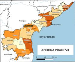
Anantapur district in Rayalaseema is the largest district in area and Srikakulam district in Uttarandhra is the smallest. East Godavari district is the most populous while Vizianagaram district is the least populous.

PHYSICAL GEOGRAPHY OF COASTAL ANDHRA:

Land defines the economics of utilization of natural resources and thus is much more than the mere terra-firma It includes "all the materials and forces, which
nature gives fieely for man's use in land and water, in air and light and heat."'
The socio-economic life of the people in any epoch is determined largely by their natural environments such as the mountains, the soils, the river-system, the flora and fauna and the weather phenomena.
Before proceeding with the land system, its
management and its cognate problems, therefore it is necessary to have a clear picture of the physical characteristics of the region under study fbm ancient sources bearing in mind at the same time the profound influence these features exercised on
Coastal Andhra economy and society.
The Coastal Andhra is the region selected for the present study.
This region is geographically located between 18" 20'- 19" 10' and 13" 3 1 '-1 5" 5 1 ' of Northern Latitude, 83" 01'-84" 54' and 79"15-80" 15' of Eastern Longitude, This region which stretches from the Srikakulam district to Nellore district of Andhra Pradesh, with its south-eastward slope looks like a waxing crescent moon.
This area covers a wide expanse of low land between the Bay of Bengal and the Eastern Ghats intersected by rivers and rivulets and indented by creeks and coves.
In some places it is extremely picturesque with long stretches of rice fields and river mouths.
Ancient port cities and trade emporiums lie scattered along the long coast-line.
The social, economic, religious and political history of this part of Andhra is in large measure shaped and influenced its geography.
The width of this Coastal plain is only 3.7 kms.
in the Srikakulan district but extended afterwards to 72 kms.
In delta and thereby paving the way for good
agricultural activities. Again, the plain's area is gradually reduced fiom 3 to 2.2 krns.
In the Prakasam and Nellore districts which form the southernmost tip of the Coastal
Andhra.
The Coastal Andhra is covered by several mountain ranges and hillocks.
The Eastern mountain ranges start hm the district of Srikakulam and extend towards
south-west up to the Godavari district.
They are nearly 610 to 1206 metres high fiom
the sea level.
From the district of Krishna these mountain ranges or the Eastern Ghats travel with breaks and they are known locally be several names, like Palakondalu, Velikondalu, Yerramala, Nallamala, Ratnagiri and Seshachalam.
The migration of Brahmins and the Vedic religion to the Andhradesa from North India is also supported by the Buddhist literary works.
As already stated above the Suttanipata relates the history of migration of a Brahmin by name Bavari from Kosala to south of Godavari.
Even the king of Kalinga honoured him by giving
a large amount of money and land for building his ararna.
The emergence of the Eastern Chalukyas of Vengi, Cholas and the Kakatiyas of Warangal gave a migration boom to the coastal Andhra desa.
The reasons are not far to seek for this boom.
The rich alluvial deposits, the flourishing trade and commerce and relatively peaceful conditions that prevailed in the region were mainly responsible for the
migration.
The land grants followed by land management and expansion of agriculture gained momentum amply attest it.
This aspect is discussed in detail elsewhere in this thesis.
It is evident from the above discussion that the natural geography of coastal Andhra has substantial significance, the long and unending Eastern Ghats with
occasional breaks, minor mountain ranges and hillocks, the rivers, rivulets, minor water resources, minor valleys, diversified climatic conditions form the very wre of
the physical geography of the region under our survey.
It shaped the economy, society, conditioned the agrarian economy, fostered agrarian industries, determined
the internal and external policies of the rulers and finally promoted both internal and international trade and commerce.
Thus, the society, economy, religion, polity and the cultural patterns of the coastal Andhradesa were determined and directed by the natural geography of the region.


No comments:
Post a Comment